Monday, December 10, 2012

Canadian Rockies: Kootenay National Park


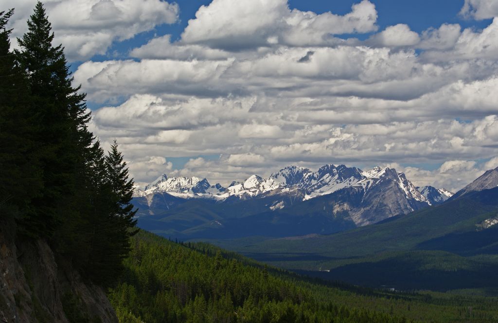
Kootenay Valley Outlook

Sinclair Canyon


I reached Kootenay National Park at 2 PM. The entrance park starts at in a city call Radium Hot Springs.  There is a fee costing $9.80 in Canadian dollars.  It was only a day pass for all the Canadian Rockies Mountains parks.  This includes Kootenay, Banff, Jasper and Yoho since the borders of each park are against each other.  Mount Robson, Mount Assiniboine and Hamber provincial parks are also located in the system.  The combined parks have been declared a UNESCO site.  I spent two days in the area exploring Kootenay, Banff, Jasper and Mount Robson parks.

The road I will be traveling is call Banff-Windermere Highway (Hwy 93 south).  The road ends at Castle Junction where it meets the Bow Valley Parkway (Hwy 1A).  Once you pass the park entrance you enter a narrow passage called Sinclair Canyon.  This canyon was original to narrow for wagons and the first owner of the hot spring used dynamite to enlarge the opening for wagons and tourist easy access to the springs.  Settlers Road was the main route used to enter Kootenay Valley before Sinclair Canyon was widened.  The road still can be traveled today but it is not paved. 

Lake Cobb Trail Parking Lot heading toward Kootenay Valley Outlook
Next stop is the park’s bathing pools fill from Radium Hot Spring waters. The spring is covered over with cement pools.  I stopped in the hot spring parking lot but decided that I would rather visit a natural hot spring than a paved over one.  This hot spring does have a small concentration of radium in it but the concentration is safe too bath in and the sulfur concentration is low enough not to smell like a rotten egg.

Kootenay Valley with Mitchell Range Mountains
Driving down the road going east you travel through Sinclair Pass.  I pulled over twice to take pictures everyone should stop at Kootenay Valley Viewpoint.  You can get a great look at the valley and the Mitchell Range.  After leaving the viewpoint I descended into Kootenay River Valley and stopped at one of the picnic areas along the river.  The river water was filled with glacier silt giving the water a grayish color.
 
Kootenay River Picnic Area

Another view of the Kootenay River
I made several stop in the valley Dolly Varden picnic area, Hector Gorge and Sir George Simpson Marker.  The scenery is breathtaking at every turn which is most likely why I love traveling in the mountains. 

Entrance to Dolly Varden Picnic Area

Hector Gorge

The view from Sir George Simpson Marker
I did not have much time to explore this park since it was late in the day but I did do to little exploring at Numa Creek Picnic Area.  Just a short walk from the parking area is Numa Falls. 
Numa Falls

Numa Falls


Numa Falls

Numa Falls


The last stop I made before leaving the park was at Stanley Glacier parking lot to photograph more mountains.

Stanley Glacier Trail Parking Lot

Note the post will not let me put any picture in it.  I will finish this in Canadian Rockies: Kootenay National Park II.  


Canadian Rockies: Kootenay National Park II


Mt Whymper from Stanley Glacier Trail Parking Lot
 I reached the Continental Divide at 4:45 PM which marks the end of Kootenay and the start of Banff.  Here is where I will stop the next part of my trip will be about Banff National Park from the Continental Divide to Lake Louis.


Continental Divide: Looking back at Kootenay National Park

Continental Divide: Look toward Banff National Park.  I think the mountain is called Castle Mountain.

Continental Divide is the end of Kootenay Park and the beginning of Banff
Note: Sorry it took so long to write about Kootenay but I first want to read more about the park.  The best book I found is Kootenay National Park by Bob Hahn.  The author worked at Kootenay as a naturalist and it an excellent story teller.  The book written is in four sections the first is about the history of the park, the second about the road traveling through the park, third section is on wildlife and the fourth about the Columbia Valley.  The second section is just great is given an in depth description and mileage marker (or a should say kilometer) of trails, lookouts, picnic and camping area in the park.

Here a list of things I wish I knew about before traveling there and someday hope to see: Paint Pots, Marble Canyon, Rockwall trail, Floe Lake, Olive Lake, Redwall Fault and many others.

The book was hard to find but worth it!

Thursday, November 29, 2012

A Little of This and a Little of That

In between posting I have been working on crossing things off my winter preparation list.  Examples are:
  • Changing out the wooden screen to storm windows
  • Cleaning out gutters after the white pine sheds all it pine needles.  Every year in the first half of October my White Pines have anywhere from a third of its needles turn yellow and fall off the tree and clog my gutters.  This year I filled five 5-gallon buckets of pine needles from the gutters.
  • Putting a tarp over the air conditioner unit.  I have central air and most people do not need to cover this unit but I do.  The reason I cover my unit  if I need to rake the snow off the roof this winter, the air conditioner unit is located near enough to the roof edge that snow falling of the roof into the unit could cause the fan blades to bend.  That could cause a problem on the motor and destroy it.  So I cover it to void any repair cost.
  • In an earlier posting “Living Room Curtains”, I show on set of curtains I finished putting a hem in.   I finished the second set in upholstery class except for hanging them and putting in the hem.   The unfinished curtains have been sitting in the dining since June and I finally found time to hem and hang them before Thanksgiving.   Having guests for the holiday always moves items up on the “TO DO LIST”.  Here is the finished project.

The living room new curtain completed.  Forgive the antenna hanging off the
curtain rod but this is the only way I can get good reception.
  • The garden been through several frosts since I pulled most of my garden in September but I did leave the all the Brussels sprouts, broccoli, 2 cauliflowers and 1 cabbage in the garden.  The weekend before Thanksgiving I harvested all those plants.  The cauliflower did not do well this year because of the drought so the heads were small.  There was enough broccoli left for two serving and an 8-inch head of red cabbage.  I have a second one in the refrigerator so my mother was the beneficiary of this cabbage.  I planted 6 Brussels sprouts plants.  The two Long Island Improved plants did poorly and one plant never formed heads.  I harvested the smaller leaved off that plants and sauté them with caramelized onion for Thanksgiving, MMM.  The Falstaff Brussels sprout did fair only forming small heads.  Jade Cross variety did the best these plants were the best producing variety I ever planted for Brussels sprouts.  I am not going to plant any Long Island variety next year.  I will still plant Falstaff because of the beautiful purple color and they taste good.  I spent the weekend after Thanksgiving blanching and freezing the sprouts.
  • Since the weather is turning cold and we had several raining weekends I did a through cleaning of the house.  Pulled up the rugs and moving furniture to wash the floor and dust and molding before Thanksgiving.  I needed to look good since Mom was coming for Thanksgiving.  The rest of the family was working over the holiday or going to theirs partner’s family event.
Revised end of  year “HOUSE TO DO LIST”
  • Cover up the 3 season porch windows with plastic inside and out.  Outside is done but this weekend I will be straightening up the porch and working on the windows.
  • Finished painting the basement floor with waterproof paint.  YES that DAMN basement still, excuse my language but I am sick of working on it.  Is this the 5th or 6th year I been working it?  Who knows!  Now that we are in the holiday season I will not be able to finish this until next year but I do plan on beginning work again in December.
Those two items are enough to work on until my new 2013 TO DO IT LIST comes out.

Saturday, November 24, 2012

Spicy Apple Upside Down Cake


I developed this recipe because I was not happy with the upside down cake recipes I tried for the Halloween Party at work.  I was not happy with it because the cake was just bland.  The people at work seems to like it but it did not meet my standards.  So I looked up several different types of Apple Upside Down Cake recipes and borrowed from them.  The most interesting was a recipe which used a boxed spice cake and that is the direction I took for the cake layer.  This cake is full of flavor and I also decide that I would be decadent by not going low fat or skipping on the sugar.  I recommend using Vietnamese Cinnamon because it is very flagrance and taste great in any recipe.


Spicy Apple Upside Down Cake


Apple Mixture

4 cups peeled and sliced apples; I used a mixture of Ginger Gold and Wolf River Apples.
1 cup apple cider
1 teaspoon cinnamon
1/2 teaspoon ginger


Bottom Layer

1 cup brown sugar
1/2 pound whole pecans
Apple Mix


Cake Mix

1-3/4 cups sifted flour
1 teaspoon baking soda
1/2 teaspoons salt
1-1/2 teaspoons cinnamon
1 teaspoon allspice
1 teaspoon nutmeg
1/4 teaspoon cloves
1/2 cup butter soften
1 cup sugar
1 egg beaten
1 cup unsweetened applesauce

Directions:

1.  Peel and slice 4 cups of apples and place them in a heavy pot.  Add cider, cinnamon and ginger to the pot.  Cook the apples over medium heat until soften but try not to over cook where they are no longer slices.  If some break up that is OK it will still taste great.  Turn off the heat when soften and allow the liquid to absorb into the apples.
2.  Grease a 9"x13" pan, line with parchment paper and grease the paper.  Spread 1 cup brown sugar and the whole pecans evenly over bottom.  Pour cooled apple mixture into the cake pan and spread it evenly.
3.  Preheat the oven to 350F. 
4.  Sift together the first 7 ingredients from the Cake Mix and put to the side. 
5.  Cream sugar and butter together.  Add beaten egg and applesauce and mix it.  Add about 1/4 of the dry ingredients to the creamed mixture and mix between each addition.  Once thoroughly mixed pour mixture into the cake pan and spread evenly.
6.  Place pan in oven for approximately 1 hour or until toothpick come out clean. 
Allow cake to cool.  The cake will be easy to turn out of the pan with the parchment.  Once cake is plated remove the paper. 
7.  Cut into pieces and serve with whipped cream.
Serves 16

This recipe was developed using the Culinary Art Institutes Encyclopedic Cookbook, 1974 Edition and a online recipe using a boxed spice cake.

Enjoy!


Thursday, November 8, 2012

Cheddar-Tomato Pie

Here another recipe my Mother gave me.  It is unusual way to use tomatoes but the pie is very good.  The original recipe just use fresh sliced tomatoes but I decided to roast the tomatoes which I believed intensified the flavor.  I served this dish with any green vegetable (pea pods, broccoli, beans, or beet greens), a mixed leaf salad and cottage cheese.

Cheddar-Tomato Pie

2    12"pie shells
2    lbs plum tomatoes (about 11 medium) roasted and peeled.
1/4 cup snipped fresh basil or 1 tablespoon dried basil.
1    cup shredded low-fat cheddar cheese (4 oz)
1/2 cup mayonnaise or low-fat salad dressing
2    tablespoons lemon juice (fresh is best)
1/2 cup shredded low-fat cheddar cheese (2 oz)

Slice the plum tomatoes in half and place cut side down in a lipped pan.  Turn on boiler and place pan with tomatoes under the burner.  Turn pan every few minutes until the skin begins to blacken.  Remove pan from boiler and pull skin off the tomato pulp.  Transfer pulp into a colander and allow the excess liquid to drain off.  The pie will have too much liquid if the pulp is not allow to drain.  I would save the liquid and add it to a stew or chili.

Roll out a 12" pie shell and transfer to pie pan.  Prepare a second pie shell for the top and set aside.  Spoon the tomato pulp into the pie pan and sprinkle with basil.  Top with 1-cup cheese.  In a small bowl stir mayonnaise and lemon juice.  Spoon over the tomatoes.  Top with the remaining cheese.

Place second pie shell on top and seal the edges by making a scallop edge.  Cut slits in pie top.  To prevent  over browning, cover edges of pie with foil.  Bake in a 375F oven 25 minutes.  Remove foil and bake for other 15 to 20 minutes or until golden.

Enjoy!

Tuesday, November 6, 2012

Canada Here I Come!

The temperature was in the upper 30’s when I woke up early at Tully Lake Campgrounds.  I knew the temperature was going to be cold the night before so I went to bed wearing long underwear and flannel pajamas.  I was nice and warm in my down sleeping bag.  Only four nights ago I took off my tent fly for the night because it was too hot.  The weather in the mountains is much colder in July.

The Northern Edge of Canal Flats
I crossed the Canadian border around 9 AM north of Eureka, MT on Thursday, July 5th.  This was the first time I crossed into Canada since a passport was required to return back to US.  The border guard asked the usually questions, "What do you have to protect yourself with".  The guard did not seem happy with my answer, "Myself" and started listed all sorts of weapons which I answers, "NO".  The next question was where I was going to visit.  So here is my agenda for traveling through Canada up to Alaska.  Kootenay, Banff and Jasper National Parks then travel west on Canada's Yellowhead Highway, Hwy 16, to Stewart Cassiar Highway, Hwy 37, where it connects to the Alaska Highway just north of Watson Lake and up the Alaska Highway to the State of Alaska after that he finally flagged me through.

It was an interesting listening to Canadian CBC News programs while driving toward Kootenay National Park.  I knew the Midwest in the US was just in the beginnings of its worst drought since the 1930s but I was unaware that area west of the Rockies in Canada and Alaska were having record rainfall causing masses flooding.  I was aware that the Alaska Highway was shut down in mid-June due to a record rain fall on snow packed mountains which caused a flash flood but did not know that it was region wide.  The Alaska highway was closed for 5 days in June between Watson Lake and Whitehorse.  I consider myself lucky that I did not encounter any problems from the excess rains during my trip north.

Columbia Lake
My first stop was on the north edge of Canal Flats on Hwy 93/95.  The wetlands and mountains in the picture was the reason I stop.  I did not know that the Columbia River headwaters were located very near here and you can hike to it on a trail called "Source of the Columbia Greenway" located in Canal Flats.  The research I did on Canal Flats came up with some interesting information.  The Columbia and Kootenay Rivers are only a mile apart from this location.  Canal Flats is on a geographical high point where the Columbia flows north and the Kootenay flows south.  A canal was build between the two rivers just when rail was taking over and rivers were no longer the highway for commerce.

The Old Coach Trail runs betweeen Radium Hot Springs and Dry Gulch along Hwy 93/95.
I stopped for lunch at a rest stop a few miles north of Canal Flats with a great view of Columbia Lake.  After lunch I kept traveling north along Hwy 93/95 admiring the meadows that lay between the mountains and Columbia River.  I took a break from driving at turnout near Dry Gulch this is the southern trail head for the "Old Coach Trail".  I walk around a little to stretch my legs and take pictures.  The north trail head starts in Radium Hot Springs and is a 9 km (6 mile) walking or biking trail that runs along the Columbia River.  If I had the time it would have been fun to do a little hiking.  I found a pamphlet for anyone who might like to hike it one day.

Mountains from the Old Coach Trail
The Overlook above Radium Hot Springs with the
Columbia River flowing along side.
I left "Old Coach Trail" head and continue north on Hwy 93/95 to Radium Hot Springs.  Just before reaching Radium Hot Spring there is a large rest area which overlooks the Columbia River and the town below.  Looking down you can see great white cliffs along the river it makes for an interesting picture. Radium Hot Spring is where Kootenay National Park begins.  I reached the entrance at 2 PM and will tell my adventure through Kootenay Park in the next blog.

Another view from the Overlook above Radium Hot Springs


Wednesday, October 31, 2012

Traveling "Going-to-the Sun Road" Part 3

Cannon Mountain left and Heavens Peak behind the pine.  This was taken from the blind lookout.
The road on the west side of Logan Pass was under construction between Big Bend to Haystack Creek and Logan Creek to Avalanche Creek.  The lookouts that were not under construction were filled with construction equipment so there were not many safe areas to stop and take pictures.

Oberlin Mountain from Loop Lookout.
Blind Lookout: Oberlin Mountain with Bird Woman Falls.


Livingston Range from the blind lookout.
I did find a cutout on the mountain side to stop and got some great pictures of Oberlin Mountain, Heavens Peak, Cannon Mountain and a panoramic shot of Livingston Mountain Range.  The cutout was located on a bend that made it tricky to get back on the road since you are blind to traffic coming in both directions.  While I was taking pictures a camper pulled over and almost got hit pulling out.  A construction vehicle was slowly navigating through the blind turn and the camper driver could not see it.  I kept yelling "STOP!" but the camper kept inching forward a little each time.  You should have seen the surprise on his face when he finally saw the trunk and his wife mouthed "Thank You" to me before departing.

The mapped routes before choosing the finally "Going-to-the-Sun Road".
I missed taking pictures at Oberlin Bend, Big Bend, Weeping Wall and the West Tunnel.  The west tunnel has ached openings with wonderful view of the valley below.  The Loop Lookout is the only switchback engineered to traverse through the mountains.  There were several routes mapped to Logan Pass before choosing this one.  One route required 15 switchbacks before reaching Logan Pass.  I did get some nice shots of Oberlin Mountain and Heavens Peck.

Heavens Peak from the Loop Lookout.
  In 2003 there were masses fires in Glacier and you can see how the land is recovering from it.

A burned area above the Loop.  Later in the summer this area is filled with blooming fireweed.
The next stop was Logan Creek where I photographed an abandon Park Ranger's Cabin before entering the second construction zone from Logan Creek to Avalanche Creek.

Old ranger's cabin on Logan Creek.  Oberlin Mountain is towering in the center with Bird Woman Fall below it.
Stanton Mountain Front Center and Mount Vaught
center rear framed with leaves.
Stanton Mountain Front Center and Mount Vaught
center rear framed with birch trees.


The turnouts were filled with cars and it was getting late so I skipped Avalanche Creek and McDonald Creek Lookouts. I found a turnout along McDonald Lake to stop and enjoyed the beautiful lake along with some great shots of a mountain framed in the trees.

McDonald Lake: Mount Vaught left behind the pine.  Cannon Mountain right peak and Mount Brown is left of Cannon.
The mountains in the background I seen referred to as the highline.
McDonald Lake with the Apgar Mountains in the background.
I drove through Apgar parking lot looking to see if I could find a quick place to stop and take more pictures before leaving.  No such luck and left the park around 6 PM and follow US 2 to Columbia Falls where I turned on Hwy 40. Hwy 40 meets up with US 93 turning north I started looking for a campsite to spent the night. I found Tully National Forest Campground on the map just 4 miles north of Whitefish. This campground is located in Flathead National Forest. Tally Lake is the deepest lake in Montana. The site was clean but it could use an upgrade compare to the Tie Hooks and other sites I been to in Michigan and Northern Wisconsin. The evening ended hearing loud bangs from the Whitefish's fireworks.

My campsite for the night.
The next day would be a long one since I crossed into Canada to visit Canada's premiere Rocky Mountain Nation Park System.