Sunday, June 16, 2013

Alaska Highway: Rancheria, Yukon to Tok Alaska

Moose Crossing Sign just north of Rancheria
I left Rancheria at 5:00 AM since I could not sleep and it started to rain.  I hate taking down a campsite in the pouring rain so I wanted to get the car packed before the rain became a steady steam.  I was planning to have breakfast in Teslin.  On the north side of the bridge there is the Yukon Motel and Restaurant, I remember eating there in 2006 when my Father and I drove the highway and their breakfast is as good as remembered it.  I made two stops before reaching the restaurant.  I just had the take a picture of another Moose Crossing sign; sorry I just cannot help myself I love those Canada's Signs.  The next stop was the turnoff above Nisutlin Bay Bridge where I took my time to admire Teslin Lake and the surrounding view.

Nisutlin Bridge from Teslin Rest Area
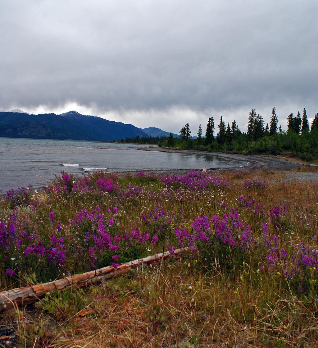
Teslin Lake north of the village.
I spent the day driving through different storm systems.  As I said earlier, the day started off with rain and just north of Teslin the skies clear up.  The second front can be seen in the pictures pushing over the mountains around the 900 mile Historical Marker.  Soon after leaving Destruction Bay I encountered rain all the way to Tok, Alaska.  In the spring of 2012 the Yukon had its fair share of bad weather and on June 8, 2012 the highway was shut down from Lake Watson to Whitehorse for 5 days due to flash flooding.  The road was washout in several sections along the route.  The flood waters were from a record rainfall and the snow melting off the mountains.  Whitehorse ran out of food and they had to flying supplies in since it was the only way into the town.  The road was repair just enough to allow traffic down the highway after 5 days, semi trunks were allow to travel the road the first day so Whitehorse could receive their badly needed supplies.

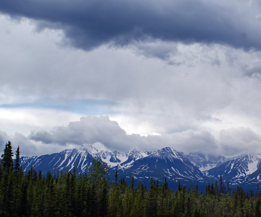
Clearing Sky between Teslin and Historical Mile Post 900
Elk Crossing Sign
The drive between Teslin Lake Village and Haines Junction was nice but my eyes kept drifting toward the distance mountains.  Some where between Jack’s Crossing and Haines Junction the Kluane and Icefields Mountain Ranges are visible from the highway.  The both ranges are a part of the St Elias Mountains.  At mile mark 986 there is a rest area that had information about Mount Kennedy and Mount Hubbard but by then it had clouded up once more and the peaks were hard to identify.  Canada declared these mountains as Kluane National Park and Reserve in 1972.  The park includes both the Icefield Range and Kluane Range of the St. Elias Mountains.  These mountains include the largest non-polar ice field in the world and the fields are the remnants from the last ice age.  Kluane is one of four parks included in the  UNESCO World Heritage Park formed in 1979.  This Heritage Park includes Wrangell-St Elias National Park and Preserve, Alaska; Kluane National Park and Reserve, Yukon Territory; Tatshenshini-Alsek Provincial Park, British Columbia and Glacier Bay National Park, Alaska.

St. Elias Mountains - Kluane Range: This is my first good view of the mountains and icefields on them.
Mount Kennedy and Mount Hubbard Rest Area
Can you find both Mt. Kennedy and Mt. Hubbard in the picture above.
A close up of the mountains.
Wild Flax were blooming along the Rest Area.
Time to hit the road again and head toward the mountain.
I pull off the road several times to take in the views along Kluane Lake.  The fields were filled with wild flowers and I stop to identify what types of flowers were blooming.  Soon after I stopped in Destruction Bay for gas and took some more pictures on the shores of Kluane Lake.  Destruction Bay has an interesting history on how it received its name.  This village was first developed as a campsite during the construction of the highway in 1940 and soon after the camp was completed it was destroyed in a wind storm.  Most of the road equipment was blown into the bay hence it name Destruction Bay.   I left Destruction Bay behind and pass through Burwash Landing before I drove through the worst section of the highway I have ever driven on.  The highway was like a wash board all the way to the US boarder.  The road was a roller coaster with pot holes in it.  So you are going up and down along with side by side for the next 138 miles.  The weather was cold and raining during the drive so I did not feel like getting out of the car to strength the legs and did not stop until I entered Beaver CreekHere I stopped for lunch and to fill the car up with gas.  The border was still another hour away (I may be stretching the time here) with more wash board like road left to travel.

The Kluane Lake view point in Kluane National Park
The lake and mountains from the view point.
The drive along the Kluane Lake changed greatly from 2006.  The road was rebuild and much of the shoreline
was filled for the new road.
A section of unaltered shoreline along Kluane Lake.
Kluane National Park: A field of wild flower along side the Alaska Highway.
Kluane National Park: Northern Yellow Locoweed
The Northern Yellow Locoweed flower.


Kluane Lake Shore in Destruction Bay
Kluane Lake looking northwest across the lake in Destruction Bay.
When I finally reached the border there were five to seven cars in front of me so I had time to get out of the car and take pictures of the international boarder between Canada and the US.  When it was my turn, the custom officer asked me if I was carry $10,000 in cash, my answer was of course was NO.  His question back was why not, I just gave him I cannot believe you said that look.  A few more questions about my profession, where I was going and only then, I was allowed to pass back into the US.  I drove straight through to Tok and found I place to slay.  I spent 13.5 hours on the road and I was ready to call it a night.

Alaska US - Canadian Border on the Alaska Highway
The next day I traveled along the Tok Cutoff and Glen Highway following east side of Wrangell-St Elias National Park until I reached the Glennallen, Alaska, here I turn southeast to Palmer before traveling the last miles to Anchorage my father’s home town.

Alaska, Here I come!

1 comment:

  1. Such a beautiful place. Thanks for sharing the photos. Jeff posted that peach salsa recipe you asked for: http://chezvorax.blogspot.com/2015/08/mild-peach-salsa.html

    ReplyDelete