Sunday, June 16, 2013

Alaska Highway: Rancheria, Yukon to Tok Alaska

Moose Crossing Sign just north of Rancheria
I left Rancheria at 5:00 AM since I could not sleep and it started to rain.  I hate taking down a campsite in the pouring rain so I wanted to get the car packed before the rain became a steady steam.  I was planning to have breakfast in Teslin.  On the north side of the bridge there is the Yukon Motel and Restaurant, I remember eating there in 2006 when my Father and I drove the highway and their breakfast is as good as remembered it.  I made two stops before reaching the restaurant.  I just had the take a picture of another Moose Crossing sign; sorry I just cannot help myself I love those Canada's Signs.  The next stop was the turnoff above Nisutlin Bay Bridge where I took my time to admire Teslin Lake and the surrounding view.

Nisutlin Bridge from Teslin Rest Area
Teslin Lake north of the village.
I spent the day driving through different storm systems.  As I said earlier, the day started off with rain and just north of Teslin the skies clear up.  The second front can be seen in the pictures pushing over the mountains around the 900 mile Historical Marker.  Soon after leaving Destruction Bay I encountered rain all the way to Tok, Alaska.  In the spring of 2012 the Yukon had its fair share of bad weather and on June 8, 2012 the highway was shut down from Lake Watson to Whitehorse for 5 days due to flash flooding.  The road was washout in several sections along the route.  The flood waters were from a record rainfall and the snow melting off the mountains.  Whitehorse ran out of food and they had to flying supplies in since it was the only way into the town.  The road was repair just enough to allow traffic down the highway after 5 days, semi trunks were allow to travel the road the first day so Whitehorse could receive their badly needed supplies.

Clearing Sky between Teslin and Historical Mile Post 900
Elk Crossing Sign
The drive between Teslin Lake Village and Haines Junction was nice but my eyes kept drifting toward the distance mountains.  Some where between Jack’s Crossing and Haines Junction the Kluane and Icefields Mountain Ranges are visible from the highway.  The both ranges are a part of the St Elias Mountains.  At mile mark 986 there is a rest area that had information about Mount Kennedy and Mount Hubbard but by then it had clouded up once more and the peaks were hard to identify.  Canada declared these mountains as Kluane National Park and Reserve in 1972.  The park includes both the Icefield Range and Kluane Range of the St. Elias Mountains.  These mountains include the largest non-polar ice field in the world and the fields are the remnants from the last ice age.  Kluane is one of four parks included in the  UNESCO World Heritage Park formed in 1979.  This Heritage Park includes Wrangell-St Elias National Park and Preserve, Alaska; Kluane National Park and Reserve, Yukon Territory; Tatshenshini-Alsek Provincial Park, British Columbia and Glacier Bay National Park, Alaska.

St. Elias Mountains - Kluane Range: This is my first good view of the mountains and icefields on them.
Mount Kennedy and Mount Hubbard Rest Area
Can you find both Mt. Kennedy and Mt. Hubbard in the picture above.
A close up of the mountains.
Wild Flax were blooming along the Rest Area.
Time to hit the road again and head toward the mountain.
I pull off the road several times to take in the views along Kluane Lake.  The fields were filled with wild flowers and I stop to identify what types of flowers were blooming.  Soon after I stopped in Destruction Bay for gas and took some more pictures on the shores of Kluane Lake.  Destruction Bay has an interesting history on how it received its name.  This village was first developed as a campsite during the construction of the highway in 1940 and soon after the camp was completed it was destroyed in a wind storm.  Most of the road equipment was blown into the bay hence it name Destruction Bay.   I left Destruction Bay behind and pass through Burwash Landing before I drove through the worst section of the highway I have ever driven on.  The highway was like a wash board all the way to the US boarder.  The road was a roller coaster with pot holes in it.  So you are going up and down along with side by side for the next 138 miles.  The weather was cold and raining during the drive so I did not feel like getting out of the car to strength the legs and did not stop until I entered Beaver CreekHere I stopped for lunch and to fill the car up with gas.  The border was still another hour away (I may be stretching the time here) with more wash board like road left to travel.

The Kluane Lake view point in Kluane National Park
The lake and mountains from the view point.
The drive along the Kluane Lake changed greatly from 2006.  The road was rebuild and much of the shoreline
was filled for the new road.
A section of unaltered shoreline along Kluane Lake.
Kluane National Park: A field of wild flower along side the Alaska Highway.
Kluane National Park: Northern Yellow Locoweed
The Northern Yellow Locoweed flower.


Kluane Lake Shore in Destruction Bay
Kluane Lake looking northwest across the lake in Destruction Bay.
When I finally reached the border there were five to seven cars in front of me so I had time to get out of the car and take pictures of the international boarder between Canada and the US.  When it was my turn, the custom officer asked me if I was carry $10,000 in cash, my answer was of course was NO.  His question back was why not, I just gave him I cannot believe you said that look.  A few more questions about my profession, where I was going and only then, I was allowed to pass back into the US.  I drove straight through to Tok and found I place to slay.  I spent 13.5 hours on the road and I was ready to call it a night.

Alaska US - Canadian Border on the Alaska Highway
The next day I traveled along the Tok Cutoff and Glen Highway following east side of Wrangell-St Elias National Park until I reached the Glennallen, Alaska, here I turn southeast to Palmer before traveling the last miles to Anchorage my father’s home town.

Alaska, Here I come!

Monday, May 27, 2013

Stewart-Cassiar Hwy North of Bell II to Rancheria Lodge on the Alaska Hwy


A bridge crossing just north of Bell II.
Bear Scat: It was hard not to step in it
there were so many piles
On July 9th I woke early again, packed up camp and stop to use the shower before hitting the road.  It was misting rain on and off during the morning.  The clouds were hanging in the trees and beautifully framed the mountain peaks I made many stops along the road to admire the view.  During my stops I found many signs of bear in the area, the gravel turnoffs were scattered with dried bear scat at least I hope it was.  You need to watch where you were stepping there were so many piles.
A black bear eating dandelions north of Gnat Pass Summit.  This is my favorite picture from the whole trip.  I spent
40 to 60 minutes sitting in the car taking pictures hoping for a shot like this.
From my readings about the Stewart-Cassiar Hwy, this is the place to see bears.  On the first day up the road I saw 4 black bears; one of the bears was dead along the road side and the rest did not stick around to be photographed.  Luckly that changed on the second day I had the pleasure to see several more bears and one bear was nice enough sit to along the road side eating dandelion seeds.  Earlier in the morning I saw a lynx casually trotting across the road looking for breakfast.  It was a treat to view it since they are shy creatures.  I did not even try to reach for my camera since he was on a mission and in no mood for pictures.  It was a real privilege just to see a lynx since they are rarely seen.
Burrage River
This remote wilderness highway will soon be lost to civilization.  Between Bell II and the Devil River a transmission company is logging along the east side of the road and putting up transmission wires.  Electricity means that more people can now can live much more easier in the back country and meaning less space for the wildlife.  Bears will be nothing more than a nuisance and the lynx will disappear.  If you want to look across the land without seeing human civilization intruding on it you should drive this road sooner than later.  It will be gone very soon.

Loons on Kinaskan Lake
About 8:30 AM I pulled into Kinaskan Lake Provincial Park and inspected campgrounds before stopping at the boat launch.  There were loons swimming near the docks, so I patiently sat on the dock hoping the loons would swim closer to me.  I took many pictures and some very nice.  It was about an hour before someone drove up with a boat to launch.  It was a nice peaceful hour enjoying the loon and the misted filled lake before I decided to move on.  Just north of the park is where I saw the lynx crossing the road.
Rest Area to the west of Eddontenajon Lake
Eddontenajon Lake

Between Kinaskan Lake Provincial Park and Dease Lake is Gnat Pass, this is the highest point on the highway at 1,241 meters (4,072 feet) above sea level.  Soon after reaching the summit I stopped to view the black bear eating dandelion seeds.  Dease Lake is where I stopped for lunch.  I ate at Mama Z Restaurant the food was delicious and service was good.

Some more of Eddontenajon Lake
Pullout between Eddontenajon Lake & Upper Gnat Lake
Upper Gnat Lake
Gnat Pass Summit: The highest point on
Stewart-Cassiar Highway (Hwy 37).

Dease Lake

I hit the road again soon after lunch and stop a Cottonwood River Rest Area and watched a group of woman fishing.  Not far north of the river is Jade City, where you can buy carved jade jewelry and other items from the family who owns the near by mine.  I enjoyed wandering through the store but passed on buying anything.   Again it was time to get in the car and keep driving north to the Alaska Highway.  I made several rest stop and one of them was at Lake Boya Provincial Park.  The lake has a lovely aqua blue color which is from the light reflecting off the marl bottom. 
Cottonwood River: Northbound Rest Area
Canadian Burnet at Cottonwood River Rest Area


Aeroplane Lake north of the village of Good Hope Lake.
American Vetch found at Aeroplane Lake.


Aeroplane Lake: Showy Locoweed or Showy Crazyweed
Scientific Name: Oxytripis splendens
Boya Lake
Boya Lake: I wished I had time to take a swim.  It just looks wonderful.
Blue Lakes was my last stop on the Stewart-Cassiar Highway.  You are looking at past damage from a forest fire.
I finally reach the Yukon Territory at 5:19 PM and Alaska Highway was just another 5 minutes away further north.  Once I reached the highway I turned northwest and started to look for a place to eat and sleep for the night.  I stopped at the historical Rancheria Lodge for the night.  The food was terrible and the campsites were OK but the outhouse looked like it had not been cleaned in weeks. 
The people running the place lost their electricity in the June 2012 flash flood.  They were running on a generator but the bath and shower room was closed but that is no reason for not having someone cleanup the outhouse daily and I did not expect gourmet food but it should taste good.

Lake behind Rancheria Lodge


Rancheria Historical Marker

Acetic Lupine at the lodge


Pickly Rose


Drawf Dogwood Bunchberry


I woke to rain around 3:30 and quickly pull and packed the tent.  I was on the road by 5:00 AM on July 10th.  The 10th was my longest day, I traveled from Rancheria Lodge to Tok, AK that day and this will be my next post.

Friday, May 24, 2013

Yellowhead (Hwy 16) & Stewart-Cassiar Highways (Hwy 37)


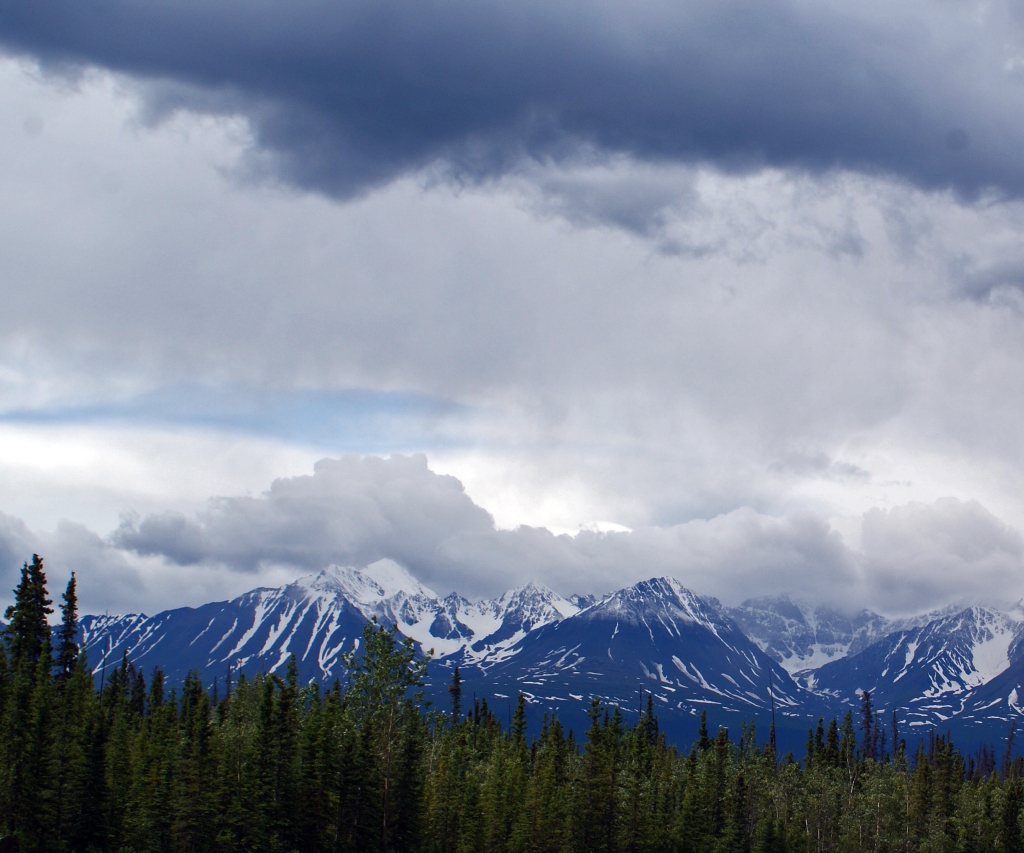
A hazy day due to the forest fires in the lower 48.  This picture was taken at a rest area on the Yellowhead Hwy between Houston and Telkwa.
As I described in The Yellowhead Hwy (Hwy 16): Jasper to Burns Lake I woke early and so afterwards started driving west toward the Stewart-Cassiar Hwy.  The sky was filled with haze it greatly reduced the visibly.  While listening to the BBC they mention that the haze was due to the large forest fires in the Western United States.  I found it interesting that the haze traveled west when most weather fronts travel west to east and I thought the mountain would have kept the smoky haze to the east but I was wrong.  The traffic was very light along the Yellowhead this early in the morning and the wildlife does make use of the highway at that time.  I saw three foxes hunting along the shoulder and one moose was travel west on it.  I was not able to stop and take pictures if I tried they would have been long gone. 
 
The Buckley River formed Moricetown Canyon.  The community fishes salmon during the run off the boulder. 
I stopped at a First Nation community called Moricetown.  There is a rest area just before the town where you can see and take some photos of Moricetown Canyon.  The residences of Moricetown fish for salmon in the rapids of Bulkley River.  The salmon were not running while I was visiting but I did get some picturesque views of the canyon. 

Moricetown Canyon from the bridge in the picture above.
Lance-leaf or Spreading Stonecrop.  If you know what it is let me know.
After exploring the canyon I turned my car west toward New HazeltonNew Hazelton has a nice Visitor Centre where I could finely get cleaned up and change out of the clothes I spend last night in.  I wish I had more time to explore the town they have the 'Ksan Museum and Historical Village which I believe would make an interesting visit.  While I was cleaning up, people were arriving and setting up a farmer's markets in the New Hazelton parking lot but did not have the time to waiting for them to open so I toured the displays inside their Visitor Centre before hitting the road.
Cow Parsnips, they perfumed the air
all around the intersection.
There is 27 miles between New Hazelton and the Stewart-Cassiar Highway (Hwy 37).  I stop at a gas station just before the junction to fill up before starting up the highway. There are long stretches along this road where there is no gas or other automobile services.  At 10:30 I started my journey up the Stewart-Cassiar Hwy.  I soon passed a road which leads to the village of Kitwanga.  If you are interested Kitwanga, it has a nice collection of Totem Pole to view.  I kept going north and but stop at Gianyow road to the village.  The whole area was blooming with Cow Parsnip and the scent from the flowers just filled the air around them.  I do not remember ever walking in a field of wildflowers and having the scent perfume the air without leaning toward a flower to smell it.  I initially stopped at the cross road to take pictures of the mountains with the flowers but the scent of the flowers is what I remember.

Gitanyow North Intersection: The meadow with the
Sheeka Mountains in the background


Nass River Bridge Rest Area
I made a few more stopped before reaching the junction to the Stewart, BC and Hyder, AK. The road is known as the Stewart Highway (Hwy 37A).  The road winds it way down through the mountains to Stewart and of coarse I had to take pictures along the way.  The most interesting stop was Bear Glacier Provincial Park.  I left after a walk along the highway try to find the best angle to photography the glacier. 

A second hanging Glacier heading down to Stewart, BC.


Hanging Glacier Along Stewart Hwy.  I have also
seen the road refer to as Glacier Hwy.

Bear Glacier viewed from the east side of the park.
Bear Glacier Mouth: I hope I am using the correct description.
Bear Glacier from the west side.
Stewart was my next stop, it was mid afternoon by the time I reached the town and I needed to eat lunch.  After lunch I explored the Visitor Centre, walked their boardwalk along the marsh, checked out the shops and explored the local museum's outside exhibits.  I want to visit Hyder, AK and Salmon Glacier but the sign post stated 50 as a distance.  The 50 was most likely in kilometers but being American I thought it was 50 miles.  It was very late in the afternoon to go that far and so I started back up the highway.
The view from Stewart's Boardwalk.
The Ripley Creek Inn from the boardwalk


I found a great t-shirt here. 


Another old building on Main Street.


Rainey's Cabin located at Stewart's Museum.
Sign on Rainey's Cabin
Stewart's Museum
Bitter Creek Bridge was washout in September 2011. 
Stranding everyone in town for 3 weeks.  The government
sent a boat to ferry the tourist out of town.
A waterfall on the way back up the Stewart Hwy.


Fireweed found on the Stewart Hwy.


Stewart Hwy (37A): Daisy
Stewart Hwy (37A): Goatsbeard


I left Stewart Highway and turned north hoping to find a place to slay the night.  Mehan Lake Rest Area was my last stopped before I called it a night at Bell II.  Bell II is a privately run lodge where you can gas up, get a nice meal and lay your head down for the night.  By the time I reach here I was dead tired and I knew if I went any farther I be in trouble.  I asked while gassing up the car if they had any tent site since all I could see there RV sites.  Yes, they did about 4-5 tent sites.  The tent sites here nice but the mosquitoes were viscous this was the first place I had any trouble with bugs.  Once the tent was up I went up to the lodge for dinner and then found the recreation area to hide from the bugs until it was time to turn in for the night.

Mehan Lake Rest Area
Close up of the Mountains at Mehan Lake Rest Area

Finally I am including a picture of me, a father and two grow sons asked me to take a picture of them and they offer to take my picture.  You can see the picnic area at the rest stop.