Saturday, December 22, 2012

December 2012 Blizzard Cleanup

It took me about 9 hours of shoveling over the last 3 days and I still have the roof to rake.  This blizzard was not as bad as the one in February 2011.  Click here if you want to compare.  Enjoy the pictures and be happy your not digging out.

I had a 3 foot drift just under the roof line that was just a little to close to the furnace inlet and outlet, so I opened up the area.


The roof needs to be raked tomorrow.  The roof vents are on the snow covered side.


Thursday, December 20, 2012

2012 Winter's First Blizzard

I woke up to this at my back door at 4 AM.  I can walk out my front door without shoveling it until I walk off the porch.  We still have more snow coming with 45 mile/hr winds in the afternoon.

Wednesday, December 19, 2012

Banff National Park: Continental Divide to Lake Louise

Visita Lake
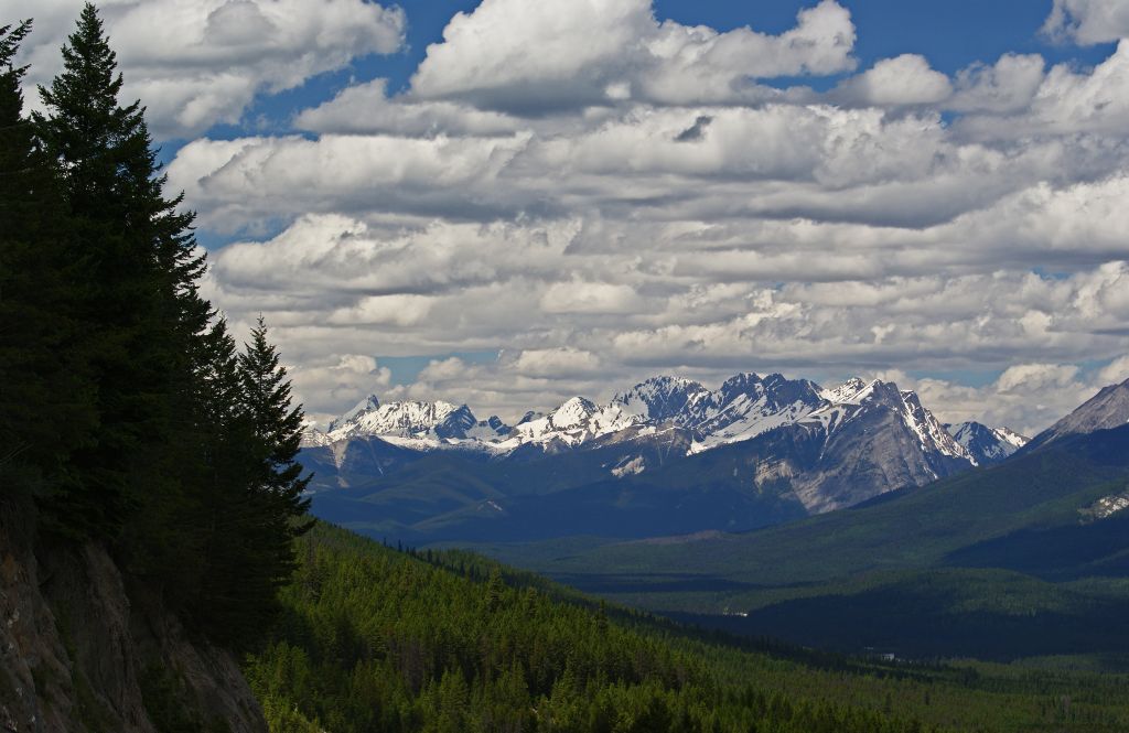
After leaving Kootenay National Park, I started looking for a camping site while taking pictures. The Canadian’s Parks do mark their campgrounds but I had trouble finding them.  My first stop was about 2 kilometers into Banff at Visita Lake Stop Viewpoint.  The lake is a beautiful greenish blue from the glacier's silt.  I shot many pictures of mountains with glaciers but I could not identify any of them.

Visita Lake Stop: View of the Mountains along the Continental Divide
I then drove on to Castle Junction, found a place to stop and take close up of Castle Mountain (I also saw them referenced as Castle Cliffs).  For a short period after World War II the Canadian government renamed Castle Mountain after General Eisenhower in honor of his service during the War.  The names was changed back but the first peak on the mountain is still named after General Eisenhower.

South end of Castle Mountain: Eisenhower Peak is to the left and named after General Eisenhower.
Castle Mountain peaks right to left: Eisenhower peak on right edge, Brewer Buttress peak, Base Buttress, Cairn Summit and the dip is called Descent Gully.
I kept moving north toward Lake Louis with no luck in finding a campsite.  Storm Mountain Viewpoint was the next stop. 

Storm Mountain and Bow River in the lower left corner.
Storm Mountain Outlook: Another beautiful view of more mountains with the Bow River in the foreground.
There was one campsite between Storm Mountain and Lake Louis but I must have missed the signed.  I stopped at Outlet Creek Viewpoint and admired the view.  If you are a railroad buff you can get a good view of Morant's Curve.  This S-shaped curve was made famous by Photographer Nicholas Morant for his pictures of trains on this curve.

Outlet Creek Outlook:  You can see a small section of Morant's Curve in the right corner.  Fairview Mountain on right edge.  Saddle Mountain is the closes.  Mount Whyte between Fairmount and Saddle.  Mount Arberdeen the large one in the center.  I am not sure about the mountain on the left, it might be Mount Temple.
After taking more pictures I was hoping to end my trip in Lake Louise campgrounds but was flagged down by people standing outside their cars watching a grizzly on the roadside.  I stop and got a very poor picture of the bear.  There was no way I was getting out of my car for a better shot. In an email I wrote my brother and sister about the bear and people below: 
  • I know you asked me to take pictures of the animals in the Park. So far I seen two eagles in a dead tree, a deer (I think), and a grizzly bear. The first two were scared away before I could take any pictures. I did get some grizzly bear shoots but none you want to paint. The real pictures I should have taken were of the people and how they behave when try to get a picture of the bear. People were getting out of their cars walking too close to the bear and the cars were blocking the highway so no one could get through. The bear was only interested in eating what he found in the grass and just wanted to put the fat on before winter. He finally reared up warning the people to back off. I am surprise no one got hurt since they were acting so stupid. Soon after that the car that was blocking me in moved so I could keep moving toward Lake Louis.

A Grizzly Bear: The large hump on its back identifies this bear as a grizzly.

Finally the people and cars moved out of my way so I could keep traveling to the campsite.  I turned into Lake Louise Village not long after seeing the bear and try to find the campsite.  I pasted the campsite entrance and ended up at the lake's parking lot and walked around thinking the campsite might be nearby.  The lake is very crowded late the evening.  I turn around heading back toward the village and then made a wrong turn in the Valley of the Ten Peak.  I found a section wide enough to make a u-turn but would not recommend anyone else doing it.  When I finally found the campground it was filled and needed to find a motel room for the night. 

3rd Floor view from my room at Lake Louise Inn.  Mountain names left to right: Mount Temple, Saddle Mountain, Sheol Mountain behind and to the right of Saddle, and Fairview Mountain.
Lake Louis Inn View
I pulled into a motel expecting to be told they were all filled up but I got lucky the person at the desk could not believe the 3rd floor in one of the buildings was empty.  That night I slay at Lake Louise Inn.  The building I slay in had no elevator but I was happy just to have a place to sleep.  The views from the 3rd floor were just something else and what a bonus.

Mount Hector from Lake Louise Inn


The next day, July 6, was a busy and wonderful day.  I made the decision that I was going to stop and hike some short trails.  I took way too many pictures of mountains, waterfalls and many different types of animals.  I only traveling from Lake Louise to Jasper and that will be the next adventure to write about.

Victoria Glacier from the 3rd floor of Lake Louise Inn

Closeup of Saddle Mountain (left), Sheol Mountain and Fairview Mountain (right edge) from Lake Louise Inn.

Monday, December 10, 2012

A Craigslist find: 3/4 oak bed

Here is the bed.  The other pillow was being washed.
For a week I was admiring this bed on Craigslist and trying to figure out where I could find room to put it.  The last few months I have been wanting to change back the front bedroom from a TV/sitting room to a bedroom.  The problem was my small house is stuffed with furniture and I need to decide what I am willing to depart with and I am still finding that hard to do.  I finely made the decision to ask if it was still available after Thanksgiving and made an appointment to see it on November 30th after work.  The bed was in good shape and the 3/4 bed is large enough for a visitor to sleep on.  I also have a queen size sleeper sofa in the living room which my brother has been sleeping on during his visits.  The gentleman who showed me the bed offer to deliver it on Sunday for an extra $45 which I accepted since I was trying to figure out how I was going to tie the mattress and frame to the roof rack.  The extra money was worth it so I would not have to move it on my own.

I spent the all Saturday moving furniture around to find room for the bed.  I finely found a configuration I liked for the living room.  It feels cozier and there is a lot more sitting area when family comes to visit. 

The new living room arrangement.
I moved the desk into the guest bedroom and just had enough room for the bed.  The hope chest was moved from the living room into my room.  Maestro love sitting on it looking out the window.  There used to be a wicker plant in front of that window I found a place for it in the living room behind the round end table.  The stand in front of the living room windows moved to where I had the hope chest and the second gold wing chair in the bedroom got moved to the basement waiting for me to decide what to do it.  Mom got first call on the chairs since she ask me to remember her if I wanted to part with one of them.

Maestro enjoying the outside.
Sunday morning all I needed to do was to setup the bed frame and help move the mattress and its frame on it.  The finishing touch was to made the bed.  I also got a mattress pad and one set of sheets for the 3/4 bed.  Now I would like to find more 3/4 sheet and maybe a nice green goose down comforter for it.

Canadian Rockies: Kootenay National Park


Kootenay Valley Outlook

Sinclair Canyon


I reached Kootenay National Park at 2 PM. The entrance park starts at in a city call Radium Hot Springs.  There is a fee costing $9.80 in Canadian dollars.  It was only a day pass for all the Canadian Rockies Mountains parks.  This includes Kootenay, Banff, Jasper and Yoho since the borders of each park are against each other.  Mount Robson, Mount Assiniboine and Hamber provincial parks are also located in the system.  The combined parks have been declared a UNESCO site.  I spent two days in the area exploring Kootenay, Banff, Jasper and Mount Robson parks.

The road I will be traveling is call Banff-Windermere Highway (Hwy 93 south).  The road ends at Castle Junction where it meets the Bow Valley Parkway (Hwy 1A).  Once you pass the park entrance you enter a narrow passage called Sinclair Canyon.  This canyon was original to narrow for wagons and the first owner of the hot spring used dynamite to enlarge the opening for wagons and tourist easy access to the springs.  Settlers Road was the main route used to enter Kootenay Valley before Sinclair Canyon was widened.  The road still can be traveled today but it is not paved. 

Lake Cobb Trail Parking Lot heading toward Kootenay Valley Outlook
Next stop is the park’s bathing pools fill from Radium Hot Spring waters. The spring is covered over with cement pools.  I stopped in the hot spring parking lot but decided that I would rather visit a natural hot spring than a paved over one.  This hot spring does have a small concentration of radium in it but the concentration is safe too bath in and the sulfur concentration is low enough not to smell like a rotten egg.

Kootenay Valley with Mitchell Range Mountains
Driving down the road going east you travel through Sinclair Pass.  I pulled over twice to take pictures everyone should stop at Kootenay Valley Viewpoint.  You can get a great look at the valley and the Mitchell Range.  After leaving the viewpoint I descended into Kootenay River Valley and stopped at one of the picnic areas along the river.  The river water was filled with glacier silt giving the water a grayish color.
 
Kootenay River Picnic Area

Another view of the Kootenay River
I made several stop in the valley Dolly Varden picnic area, Hector Gorge and Sir George Simpson Marker.  The scenery is breathtaking at every turn which is most likely why I love traveling in the mountains. 

Entrance to Dolly Varden Picnic Area

Hector Gorge

The view from Sir George Simpson Marker
I did not have much time to explore this park since it was late in the day but I did do to little exploring at Numa Creek Picnic Area.  Just a short walk from the parking area is Numa Falls. 
Numa Falls

Numa Falls


Numa Falls

Numa Falls


The last stop I made before leaving the park was at Stanley Glacier parking lot to photograph more mountains.

Stanley Glacier Trail Parking Lot

Note the post will not let me put any picture in it.  I will finish this in Canadian Rockies: Kootenay National Park II.  


Canadian Rockies: Kootenay National Park II


Mt Whymper from Stanley Glacier Trail Parking Lot
 I reached the Continental Divide at 4:45 PM which marks the end of Kootenay and the start of Banff.  Here is where I will stop the next part of my trip will be about Banff National Park from the Continental Divide to Lake Louis.


Continental Divide: Looking back at Kootenay National Park

Continental Divide: Look toward Banff National Park.  I think the mountain is called Castle Mountain.

Continental Divide is the end of Kootenay Park and the beginning of Banff
Note: Sorry it took so long to write about Kootenay but I first want to read more about the park.  The best book I found is Kootenay National Park by Bob Hahn.  The author worked at Kootenay as a naturalist and it an excellent story teller.  The book written is in four sections the first is about the history of the park, the second about the road traveling through the park, third section is on wildlife and the fourth about the Columbia Valley.  The second section is just great is given an in depth description and mileage marker (or a should say kilometer) of trails, lookouts, picnic and camping area in the park.

Here a list of things I wish I knew about before traveling there and someday hope to see: Paint Pots, Marble Canyon, Rockwall trail, Floe Lake, Olive Lake, Redwall Fault and many others.

The book was hard to find but worth it!